

For centuries, the Silk Road has been imagined as a southern route, a path that connected China with the great cities of Samarkand and Bukhara. Yet, recent research points to a different story—one in which a northern corridor along the Syr Darya River actually served as the principal artery of trade between East Asia and the Golden Horde. Now, as long-buried cities along this route re-emerge from beneath the sands, this forgotten network is reshaping our understanding of Central Asia’s place in global history. What was once seen as a peripheral region is beginning to look more like a central crossroads that connected empires, cultures, and peoples.
- 1. Rethinking the Silk Road
- 2. Early Trade and Regional Exchange
- 3. The Mongol Transformation
- 4. The Rise of the Northern Silk Road
- 5. Cities of the Steppe: Culture, Trade, and Diversity
- 6. Decline and Redirection: Timur and the Shift South
- 7. Britain’s Bid to Redirect Silk Road Trade
- 8. Russia’s Expansion and the Transformation of Central Asia
The Silk Road was not a single road, but a vast network of trade routes stretching across Asia. Yet, in the public imagination, it is usually associated with a southern route that passed through the great cities of Samarkand and Bukhara. Recent evidence suggests a different picture, for hundreds of years, until its decline in the sixteenth–seventeenth centuries—a more northerly route, following the course of the Syr Darya River through lesser-known cities such as Otyrar, Turkistan, Sygnak, and Sauran, was far more important. It served as the main line of communication and trade connecting the Russian lands under the Golden Horde with other parts of the Turko-Mongol Empire.

Aerial view of the Otyrar settlement. Contemporary photograph / Alamy
Rethinking the Silk Road
Ever since the concept of the Silk Road was coined in 1877 by the German geologist Ferdinand von Richthofen (uncle of the First World War’s top-scoring flying ace), scholars have debated what, precisely, this all-embracing term means. ‘A route by which silk was transported overland from China, across the deserts of Central Asia to Europe’, might be an obvious explanation, but that only raises more questions than it answers.

Ferdinand von Richthofen, German geographer and explorer of Central Asia. Germany, late 19th century / Wikimedia Commons
Was it just China? Or should we include Japan, Korea, India and elsewhere? Was it just silk, or was it primarily a trade in horses, as argued by David Chaffetz in a recent booki David Chaffetz, Raiders, Rulers and Traders: The Horse and the Rise of Empires, New York: 2024? And was the Silk Road a specific route, or a vast assortment of tracks, roadways and paths connecting hundreds of towns and cities throughout Asia? Everyone seems to have a different answer. But whatever the scientists and historians may think, in the age of mass tourism at least, the concept has become increasingly associated with the Central Asian cities of Samarkand and Bukhara in particular, and further east, with Kashgar and Yarkand.

Caravan of camels resting. Antioch. 19th-century colored engraving / Getty Images
Early Trade and Regional Exchange
These first two cities became important in relation to the Silk Road trade in the late fourteenth century at the time of Amir Timur, who made Samarkand his capital (and burial place) and endowed it with a profusion of remarkable buildings. But this had not always been the case. Although silk has been valued as a luxury item as far back as the Romans, in those early days the Chinese empire had not been particularly concerned about exporting goods westwards across the deserts of Central Asia. Trade tended to be local, between neighbouring towns and cities, particularly following the periodic expansion of the Chinese Empire into Inner Asia and in the wake of the spread of Buddhism. Only later did the Silk Road become important in terms of international trade.

Mural of Amir Timur at the Amir Timur Museum. Tashkent, Uzbekistan, November 10 / Getty Images
The arrival of the Arabs into southern parts of Central Asia and Turkic peoples into the more northerly and central areas from the seventh century onwards acted as a brake on trade with China. The Arabs in particular, responsible for the growth and status of Samarkand and Bukhara at that time, mainly looked towards Baghdad or Iran for trade.
More about
PASSPORTS, INNS, AND EXPRESS DELIVERY IN THE THIRTEENTH CENTURY
What Travel Was Really Like on the Silk Road—and Why It Was Far More than a Caravan Highway
The Mongol Transformation
The main reason for the expansion of trade along the growing Silk Road was the arrival of the Mongols and their allies in the early thirteenth century. Within just a few decades the armies of Chinggis Khan conquered much of Eurasia. Ruling such a vast empire required a highly developed communications network, based on the Yam system (known as örtöö in Mongolian) of post stations and relay couriers. This system enabled rapid communications between the Mongol capital at Karakoram and the various uluses far to the west.

A Mongol courier carrying a letter across the Gobi Desert / bridgemanimages.com
Following the death of Chinggis Khan in 1227, the empire was divided among his four sons—Jochi (who had died earlier, around 1225–1227, and was succeeded by his son Batu), Chagatai, Ögedei, and Tolui. Together with their descendants, they controlled vast territories across Central Asia, as well as China, southern Russia, Iran, and eastern Turkistan, while acknowledging the authority of the Great Khan at the center of the empire.
The Mongol Yam system of strictly controlled, well-equipped and strongly-protected posthouses formed the real backbone of the Silk Road, along which the Mongols could send troops, weapons, provisions, even fodder for their horses and camels. Later, as the Mongols consolidated their empire, luxury goods formed much of the cargo. Not surprisingly, the most challenging route to the west was to the most distant, namely Batu’s Golden Horde, which controlled all the land west of Lake Balkash and the Urals, as far as Moscow.
Under this Pax Mongolica, trade goods increasingly flowed directly out of China, especially after Chinggis Khan’s grandson, Kublai Khan, established the Yuan dynasty and ruled as emperor.
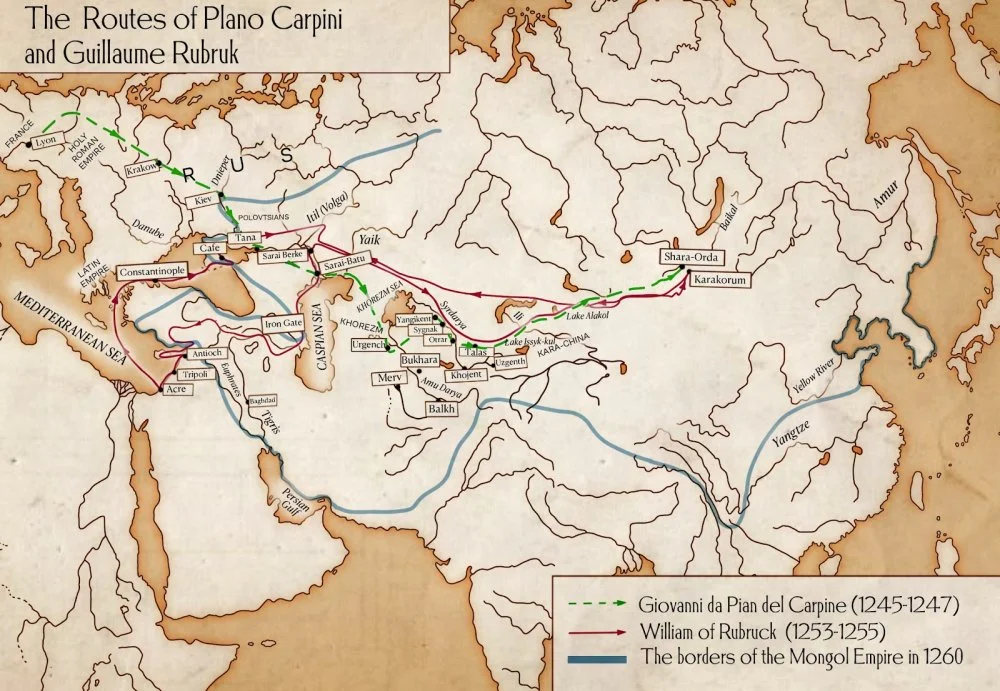
The two main caravan routes skirted the great Taklamakan Desert in present-day Xinjiang - a northerly path via Hami or a more southerly route that hugged the mountain massif to the north of Tibet. Those taking the northern path still had the option of heading to Kashgar and reuniting with the southern route or striking off to the northwest, following the course of the Syr Darya River to the north of the Aral Sea and then on to the Volga Delta and Batu’s capital at Sarai.
The Rise of the Northern Silk Road
This north-westerly route along the Syr Darya, which can be referred to as the Northern Silk Road, took the caravans through the cities of Isfijab (now Sayram), Otyrar, Turkistan, Sygnak, Sauran, Jend and Yangkent (or Jankent), and across the top of the Aral Sea, before the long desert crossing to the Volga Delta and then on to the heartland of the Golden Horde around the cities of Sarai and Kazan, or westwards to the Crimean khanate on the Black Sea.
Qalam
Some caravans took an even more northerly ‘Ili’ route from China, coming from Hami and Turfan through the Dzungarian Gate close to lake Alaköl before making their way south of Lake Balkash, across the Ili River and through what is now the Jetisu region of Kazakhstan. Indeed, it is significant that this was the route chosen (in reverse) in the thirteenth century by two of the earliest European visitors—and papal envoys—to Central Asia, the priests William of Rubruck and Giovanni da Pian del Carpine, as they travelled towards the Mongol capital at Karakorum. This indicates just how well established this route had become.
Cities of the Steppe: Culture, Trade, and Diversity
Rubruck gives a detailed description of his stay at Kayalyk (Qoilyq) in 1254, a large Karluk city 190km north of Taldykorgan in the Jetisu, close to Lake Balkash, where its ruins can be foundiThe Mission of Friar William of Rubruck (tr. Peter Jackson), London: 1990. He notes that the town contained mosques, Buddhist temples and Nestorian churches and that many of the townspeople were Persian-speaking.

The author inside the ruins of a Buddhist temple at Kayalyk in Jetisu / Courtesy of Nick Fielding
From Kayalyk, those travellers coming from China or Mongolia could make their way southwest via the Jetisu cities of Aktam, Karamergen and Agashayak towards Taraz and Isfijab, before joining the route along the Syr Darya. Little now remains of these Jetisu cities, many of which were destroyed by the Mongols in the thirteenth century and never rebuilt.
Successful archaeological digs at some of the ruined cities scattered along the Syr Darya have led to all the present-day states in the region drawing up recommendations for many of them to be included in the list of UNESCO World Heritage sites. Kazakhstan, for example, has drawn up a list of nine archaeological sites, located in what is referred to as the Fergana-Syr Darya CorridoriК.М. Байпаков, Д.А. Воякин. Казахстанский отрезок Великого Шелкового пути в серийной номинации ЮНЕСКО. Алматы: 2012. This in turn links up with the 5,000-km Chang’an-Tian Shan Corridor that stretches westwards from Chang’an in central China to the Tian Shan Mountains in present-day Kyrgyzstan and whose 33 cities flourished between the 6-sixteenth centuriesi‘The Chinese Section of the Silk Roads’, https://whc.unesco.org/en/tentativelists/6093/.
The Ferghana-Syr Darya UNESCO submission for Kazakhstan describes each ancient city in detail, highlighting its historical significance, architectural features, periods of prosperity and decline and the results of archaeological researchi‘Silk Roads: Fergana-Syrdarya Corridor’, https://whc.unesco.org/en/tentativelists/6568/. Otyrar, for example, located close to the city of Turkistan, was a major administrative centre before its destruction by the Mongols, with a sophisticated irrigation system and trade connections to many regions. Almost all these cities along the Syr Darya relied on sophisticated irrigation systems, both for drinking water and for crops. In 1200, Otyrar’s population was 200,000, at a time when London had 40,000 inhabitants, Paris 110,000 and Venice 70,000.

The gate of Shakhristan at the ruins of Otyrar, Kazakhstan/Getty Images
Other cities on the Fergana-Syr Darya UNESCO list include Asanas, which was a crucial trade hub with the Aral Sea and Khorezm regions; Kyshkala, located near Kyzylorda, which flourished in the Middle Ages, but declined due to changes in the course of the Syr Darya and regional conflicts; Sygnak, whose 20-acre site was the capital of the Qipchaq state and later the Aq Orda (White Horde); Sauran, known for its massive (still surviving) fortification walls, moat and necropolis; Jankala, close to the Aral Sea, which is associated with the historical city of Jend and features a citadel, sharistan, rabad, caravanserais and extensive irrigation works; Jankent, which was the capital of the Oghuz state and a major fortified trading centre with burial grounds dating back to the 1stC BCE; near to both Jankala and Jankent is the Jetiasar Oasis, about 90kms south of Baikonur space station in the Kyzylorda region, and which contains a unique concentration of towns, settlements and burial grounds associated with the Kangju or Sogdian State. Caravans travelled from the Tian Shan via this oasis as far as Atil in the Volga delta.

Walls of Sauran / Courtesy of Nick Fielding
Nor should we forget the city of Turkistan, with its famous Timurid mausoleum for Khoja Ahmad Yasawi, one of the greatest of all the Timurid buildings. The city is built over the ruins of Yassy, which by the Middle Ages had become a commercial and religious hub, serving as a link between Central Asia, China, and the steppe. It later became the capital of the Kazakh Khanate, enhancing its regional role beyond trade.
More about
HORSES, TEA, AND THE WORD OF THE NOMAD
How the Kazakh Khanate’s Economy Worked—and Why It Was Far More Complex Than It Seems
Many of these cities were founded and flourished well before the Mongol conquest in the 12th-13th centuries, but trade was mostly local. Some, like Otyrar, which had been destroyed by the Mongols, rose again once the Golden Horde had established itself across Central Asia and southern Russia. Its jurisdiction eventually stretched from its centre along the Volga as far as the Aral Sea in the south. As previously described, this was the time when trade from China and India across Central Asia really began to expand, initially simply to ensure the Mongol army was supplied with all it needed.

Mausoleum of Khoja Ahmed Yasawi commissioned by Timur. Turkistan, Kazakhstan / Getty Images
Nor was it just the Golden Horde that benefitted from this trade. As Charles J Halperin notesiCharles J. Halperin, Russia and the Golden Horde (London: 1985), 85:
“Until at least the sixteenth century Muscovy remained deeply involved in oriental trade, particularly with Persia, as did Yaroslavl and the annexed Volga khanates of Kazan and Astrakhan.”
Decline and Redirection: Timur and the Shift South
However, after almost 200 years which saw a huge expansion in trade and the increasing involvement of European merchants, this golden age of the Northern Silk Road was brought to an end with the defeat of the Golden Horde by Timur in 1391. Having conquered the region, Timur turned his back on Russia and diverted much of the Northern Silk Road trade from the Syr Darya cities towards Samarkand and Bukhara.

Shah-i-Zinda architectural ensemble, a Timurid necropolis of the 14th–15th centuries. Samarkand, Uzbekistan / Getty Images
As this trade expanded and merchants found new routes to Europe via Iran, the newly wealthy members of Timur’s court were able to build beautiful palaces, mosques and madrassas in both cities and surround themselves with luxuries. Even today, despite depredations over the years, both Samarkand and Bukhara retain much of their beauty and still impress with their extraordinary textiles, architecture and literary history.
With little left of the Golden Horde, the caravans that once sustained it now diverted towards more lucrative markets, travelling southwest from Samarkand towards the great cities of Merv and Herat, and then on to Iran and into the Ottoman cities of Antioch and Tyre on the east coast of the Mediterranean in what is now Lebanon. The trade was dominated by Iranians who were happy to sell their wares to Venetian and Genoan traders on the coast who in turn resold their valuable cargoes across Europe - evident from the number of fine Turkish and Persian carpets that began to appear in European paintings.

Johannes Vermeer. The Sleeping Girl. 1657. Metropolitan Museum of Art, New York / Wikimedia Commons
Timur’s destruction of dozens of cities and their inhabitants did not provide a model for stable imperial government, even if it allowed him, for a time, to amass vast amounts of wealth to finance the beautification of Samarkand, Bukhara, Tashkent, and—most beautiful of all—Turkistan. Under his rule, Samarkand became one of the largest cities in the world, its wealth derived from the plunder of large parts of Central Asia, Iran, the Middle East, and northern India, as well as from the exploitation of their populations. After his death, his successors inevitably fell out with one another, and his empire began to collapse.
Britain’s Bid to Redirect Silk Road Trade
By the middle of the sixteenth century — and particularly after the destruction by Ivan the Terrible of the khanates of Kazan and Astrakhan in the 1550s – the remaining trade along the old Northern route of the Silk Road was in steep decline. Cities along the Syr Darya that had once relied on the caravan trade were now abandoned or became shadows of their former selves. Security, once guaranteed by the ruthless Mongol troops, collapsed. When the British merchant adventurer Anthony Jenkinson reached Bukhara in 1560, he was unable to continue his journey east because of numerous conflicts that had broken out along the route.

Anthony Jenkinson’s original map. 1562 / Wikimedia Commons
He was part of a small group of British merchants in the Muscovy Company who still believed that there could be an opportunity to steal much of the Silk Road trade from the Genoese and Venetians operating in the Eastern Mediterranean and the Black Sea. Their idea was simple: divert the trade north again, either from Samarkand and Bukhara or northwards across the Caspian Sea from Iran towards Astrakhan and the Volga. Using the Russian rivers, goods could be taken to the White Sea in the far north and then transported by ship to England. Instead of Venetians and Genoans making super profits from trading in silk, jewels and spices, it would be English merchants controlling the trade.
As Michael Locke, a Muscovy Company agent stated at the timeiSamuel H. Baron, The Travels of Olearius in seventeenth-century Russia (Stanford: 1967), 4:
“The traffic of Persia through Russia would be of exceedingly great importance to England for jewels, silks, drugs, galls [an insect product, used in tanning and dyeing], alum, and other merchandises there to be had at their fount; all of which might pass safely, without danger of the Turk, and without knowledge of Italy and Spain, and with no license from the King of Portugal. And all those commodities of Russia and Persia would pass abundantly by this North Sea into England and through England out again into Flanders, Germany, France, Spain and Italy, through the hands of Englishmen.”
The Muscovy Company received its royal charter in 1555 and within two years had mounted its first expedition to Central Asia via Moscow. Anthony Jenkinson set out from London on what was the first of four expeditions he would mount to try and unlock the wealth of the Silk Road, eventually reaching Bukhara on his first journey and in the process becoming the first European to sail on the Caspian.

Kalyan complex, an architectural ensemble with the Kalyan minaret, mosque and Mir-i-Arab madrasa. Bukhara, Uzbekistan / Getty Images
He would also go on to visit Iran twice in an effort to make the business work. In fact, between 1557 and 1581 six English expeditions were sent down the Volga to Iran. When the Russian Tsars deprived the company of the right of free transit in the 1590s, the English opened trade relations in the Persian Gulf. They concluded an alliance with Abbas the Great, Shah of Iran, in 1620 and forced the Portuguese to abandon their bases in the Persian Gulf. In this way they began to undercut the Genoans and Venetians in the Mediterranean and to establish the basis for a British Empire.
By that time, of course, the international maritime trade was expanding dramatically. New sea routes to the East meant goods were generally safer and no longer subject to the depredations of bandits across the steppes. Although the Muscovy Company’s efforts to divert trade to the north were ultimately unsuccessful, even in the eighteenth century English merchants were still trying to find a way of diverting the Iranian trade northwards to Russia. In September 1743, for example, the English merchant Jonas Hanway left St. Petersburg for Moscow, Tsaritsyn and Astrakhan, where he took a ship across the Caspian Sea to IraniJonas Hanway, An Historical Account of the British Trade over the Caspian Sea, with the Author’s Journal of Travels (London: 1754).

James Northcote. Portrait of Jonas Hanway, English merchant, traveller and philanthropist. c. 1785. National Portrait Gallery, London / Wikimedia Commons
Little came of Hanway’s efforts; much of his cargo was stolen, he became ill and his ship was attacked by pirates. That, it seems, was the end of attempts by the British to divert the trade to the north. For the next 100 years or so, the cities of Central Asia continued their steady decline, left behind by a world increasingly dominated by the new modes of transport.
Russia’s Expansion and the Transformation of Central Asia
With the construction of the Transcaspian Railway in the late nineteenth century, following Russia’s conquest of the khanates, travel to and within Central Asia became much easier. In fact, the military railway that the Russians opened in Spring 1888 as part of their project to control this vast region eventually became the main route into the heart of Central Asia. From the Caspian coast it passed through Ashgabat and Merv before reaching Bukhara, Samarkand and Tashkent. As soon as the railway opened it became a favourite with aspiring European tourists who could now reach the Registan in Samarkand almost without getting dust on their shoes.

Trans-Caspian Railway, arrival of the first train in Samarkand, 1890 / Wikimedia Commons
At the same time, the fact that the new railway skirted the Syr Darya but took in both Samarkand and Bukhara only reinforced the view that these two cities were the most important survivors from the time of the Silk Road. Even before the beginning of the twentieth century the old Northern Silk Road had been almost completely forgotten.
More about
BUTTER, COPPER, AND A CRUMBLING EMPIRE
British Encounters with Early Industrialization in the Kazakh Steppe
Today, as the ancient cities along the Syr Darya are mapped and excavated, the importance of the Northern Silk Road is increasingly coming into focus. It is already evident that during much of the early modern period it was the principal Silk Road trade route from Mongolia and China across the Central Asian deserts to the territory of the Golden Horde, including Southern Russia. These riverine cities, well protected by the Mongols’ Yam system of posthouses, ensured both safety and efficiency along its length. It collapsed for two reasons; first, the military campaigns of Amir Timur, which diverted trade to his favoured cities of Samarkand and Bukhara; and second, the destruction of Kazan and Astrakhan by Ivan the Terrible in the 1550s. The simultaneous opening of maritime routes to the far east put the final nail into the coffin.

Crossing the Syr Darya. Woodcut, 19th century / Getty Images
However, as the ruins of these cities continue to emerge from beneath the sands, we can expect a wealth of important archaeological discoveries that will reshape our understanding of both Central Asia and the Silk Road.
