
‘A good name is better than wealth’ says a Kazakh proverb. As odd as this adage may sound when discussing Almaty—whether when speaking of its history as a medieval city situated on the Silk Road, its significance as a strategic point for Timur's regional expansion, its role as a winter stopover for nomadic tribes, or its status as a Cossack stronghold—it is the name itself that has stood the test of time, enduring earthquakes, invasions, and numerous changes. The city’s name has continued to live its own life even through periods when habitation in it was temporarily interrupted, and the name of the city echoed in the courtyards of the Great Mughal Empire and in the Catholic monasteries of medieval Europe, though for entirely different reasons.
‘After the Russians occupied the Zailiisky (Trans-Ili) Valley, a fortress named Vernoye was established on the site where the medieval city of Almaty, also known as Yablonny [‘Apple City’], once stood, renowned for its trade and serving as a station on the caravan route for many peoples, including Genoese merchants traveling to China,’ wrote the Russian scientist Nikolai Sorokin about his journey to the Tian Shan Mountains in 1884. In addition, Genoese merchants returning from China also brought back fragmented information about Almaty to Europe, including tales of Saint Matthew’s relics stored in a Nestorian church. The curious minds of the listeners logically connected these two things because ‘Almaty’ sounded similar to ‘Matthew’ in Arabic but with the definite article 'al'. The myth about Saint Matthew’s relics also eventually faded away when it became clear that it was actually referring to the Apple City.
In this article, Anna Bronovitskaya, an architectural historian and the co-author of the book Alma-Ata: Architecture of Soviet Modernism in 1955–1991, tells us about the architectural evolution of Almaty. Dennis Keen, a Kazakh language instructor at Stanford University and the author of the Walking Almaty and Monumental Almaty projects, shares his insights about lost Kazakh toponyms and the indigenous Kazakh residents of Almaty.
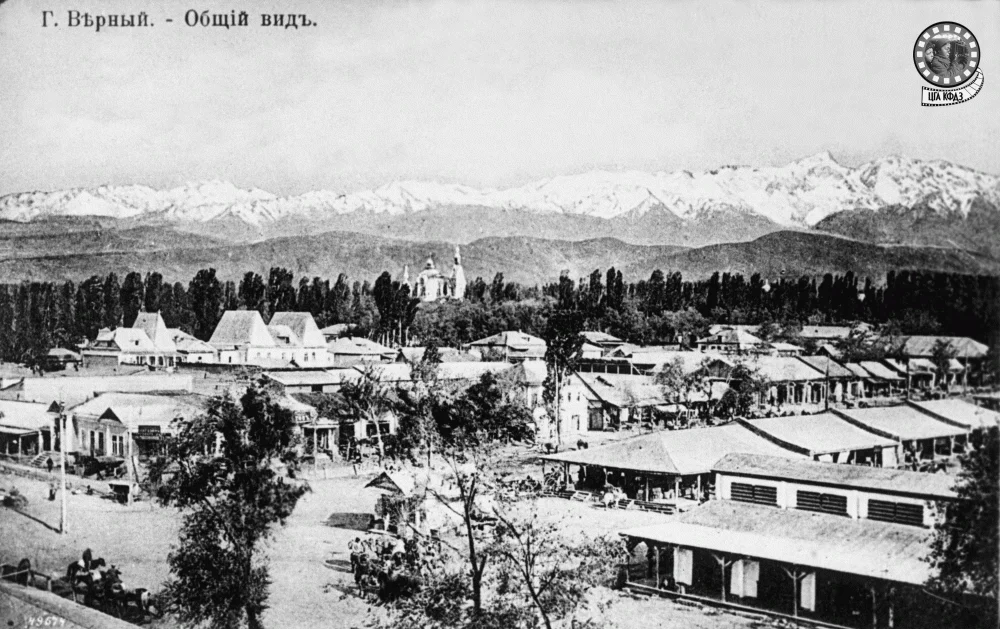
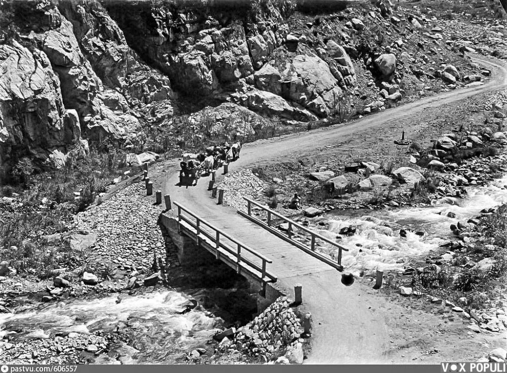
City of Verny/CGA KFDZ RK
The City of Verny
Anna Bronovitskaya:
According to the accounts of the famous explorer Pyotr Semenov, who would later change his surname to Semenov-Tian-Shansky (meaning Semenov of Tian Shan), the Russian colonization of the Trans-Ili Alatau region, which he described as 'more grandiose than the Swiss Alps', was marked by bloody conflicts with the Kazakhs.There were also conflicts later with the Kyrgyz, whom he, in the spirit of the Russian nomenclature of that time, referred to as 'Kara-Kyrgyz' (sometimes 'wild-stone Kyrgyz') since the term 'Kyrgyz' was used to denote the Kazakhs. He also recalls instances of local Kazakhs attacking Cossack herds immediately after the Russian settlements were founded. These clashes ended with a display of the severed heads of Cossacks impaled on pikes. There were also attacks on Russian caravans and prisoners were captured, whom, according to Semenov, the Kazakhs sold into slavery in Khiva.
Approximately thirty years later, in 1883, Semenov, however, described a very different picture. ‘Nowadays, Verny, undoubtedly the best and most flourishing Russian city in Central Asia, has 17,000 inhabitants, many good two-story stone houses, a beautiful and spacious stone guest yard, and two churches with beautiful architecture. But the greatest adornment of Verny is the beautiful gardens cultivated around the city by Russian settlers.’
Initially, the settlement grew near a fortress located at the intersection of the Kulja Road and the Malaya Almatinka River (in Kazakh, the Kishi Almaty, or the Little Almaty River). On either side of the fortress, stanitsas, or Cossack military settlements, appeared, where Cossacks and peasants moved to from the European part of Russia and western Siberia. These villages soon became Great and Little Stanitsa, among Almaty’s first neighborhoods. The people here engaged in agriculture and crafts, supplying the military garrison with all necessary goods. The new settlement attracted merchants from Tashkent and Tatar merchants, whose yards formed the Tatar sloboda (free settlement) on the opposite bank of the Little Almaty River. The Tatar sloboda formed spontaneously, while both stanitsas were given a simple, regular layout, which can still be seen in the city plan, although the construction has completely changed. Each stanitsa had its own church and school, and in the Tatar sloboda, there was a mosque with a school. The Kazakhs, on the other hand, being nomads, did not live in the city but roamed the surrounding areas, gradually retreating from irrigated lands to the steppes and mountains under pressure from Russian settlers.
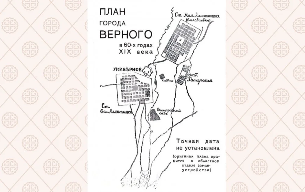
Verny City Plan/Wikipedia Commons
[Qalam]:
The problem with researching the history of the Trans-Ili Alatau region during the period of Russian conquest, including the history of the foundation of the Verny fortress, lies in part in the fact that the colonization of the region is often depicted in Russian sources as the occupation of vacant and unclaimed lands and the displacement of some nomadic elements, who had no particular spiritual connection to this area, to the mountains. However, this tragic rupture, with all its associated material, sociopolitical, and spiritual components, is well-documented in folk memory. This is evident in the meticulous fixation on toponymy in family memory and folklore, a practice that persisted even during the Soviet period, and Almaty and its surroundings were no exception. Besides the obsession with calling places by their native Kazakh names, there are many literary mentions of the tragedy of parting with Almaty in Kazakh songs and poems, some of which were collected and published in 1894 by the Russian orientalist Nikolai Veselovsky:
‘I have been shedding tears like rain, and I will tell this story sobbing ...
In my land, called Almaty, the unfaithful settled.
Due to carelessness, you let go of my land, called Almaty,
My brilliant, bright rose, and thirty thousand homesteads of my people.’
It is interesting to note that the song ‘Almaty, My Flower’ (in Kazakh ‘Gül Almatym’) has been sung for a long time in the country by many artists, including Yermek Serkebayev and Batyrkhan Shukenov.
Meanwhile, the indigenous population of these lands, the Kazakh tribes of the Senior Jüz (Uly Jüz), who had lost their lands and were forced to wander the vicinity, were increasingly perceived by colonial authorities as aggressive and destructive elements. The Russian military geographer Mikhail Venyukov was irritated by the ‘patriarchal landlessness’ of the Kazakhs who roamed ‘the streets of Almaty’ as they did the steppe. He wanted the Kazakhs to take a significant step towards forming a civilization in the future, transitioning from the life of nomadic hunters to mere peaceful shepherds.
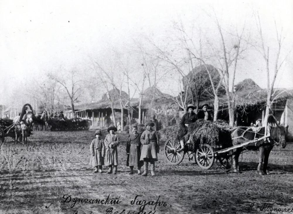
Dungan Bazaar, Verny/Wikipedia Commons
Dennis Keen:
It’s a phrase, ‘native Almatian’, that’s become a boastful shibboleth for Almaty-born locals. To be a ‘korennoi almatinets’ is to distinguish the born-and-bred from the mostly rural migrants who have doubled Almaty’s population in the thirty years since Kazakhstan’s independence. But if you dig into family histories, some of this supposedly indigenous class have long-standing ties to this land. As the capital of Soviet Kazakhstan, Almaty (or Alma-Ata as it was then known in Russian) became a place of mass resettlement, especially during the Stalinist era. During this time, Almaty became a place of wartime evacuation for Slavic factory workers and a place of internal exile for Koreans, people from the Caucasus, and other repressed groups. These settlers and deportees would eventually assimilate to a city that was culturally Russian, and their descendants now bear the title of ‘native’ with pride.
The real ‘native Almatians’, meanwhile, were frequently marginalized. During the tumultuous years after the October Revolution, many important local families sided not with the communists but with the Alash Orda Movement that advocated for Kazakh autonomy, and they were subsequently ignored by Soviet historians. In the early 1930s, local Kazakhs starved en masse in the genocidal famine known as Asharshylyq, and those that survived were forced by the Soviet system of residential permits, or propiska, to live on rural state farms, or kolkhoz, surrounding the capital. The Kazakh elite in the city center, especially the intelligentsia comprising writers and academics, were largely drawn from the Middle Jüz (Orta Jüz), a tribal confederation from central and northern Kazakhstan known for its intellectual contributions. To be sure, prominent Communist leaders such as Dinmukhamed Kunayev and Nursultan Nazarbayev had local roots, but native Kazakhs were largely outnumbered, and the greater part of their history has been effectively erased.
To remember these authentic local Almatians is to resurrect a history of the area that predates its colonial identity and to understand it in the terms of its indigenous inhabitants. This is a place where the Kazakh tribes of the Senior Jüz (Uly Jüz)—mostly Alban, Dulat, and Shapyrashty—once traced their nomadic paths, migrating from the highlands of the Alatau Mountains to the steppe of the Ili River Valley. It is part of the larger cultural and geographical region known as Jetisu, or the Land of Seven Rivers—it is also known as the Land of Batyrs and Aqyns, of Kazakh warriors and poet-musicians. Remnants of these native heroes can be found in local toponyms and monuments, but they are lost beneath the urbanization of the area in the twentieth century. This applies as well to Medeu, a person who gave Almaty the land for one of its best-known structures, but whose life story has been lost and forgotten in the midst of social and political upheavals and transformations. However, his name remains, albeit associated with a monument of modernism. So, in this era of decolonial consciousness, we can finally attempt to shift our focus to the real person, his land, and his roots.

Verny City/Wikipedia Commons
Anna Bronovitskaya:
In 1867, the Semirechye region (known as Jetisu, the Land of Seven Waters, in Kazakh) was formed as a part of the Russian Empire, and Verny began to emerge as its administrative center. The city planning committee developed a layout with a standard rectangular grid of blocks for the nineteenth century. The streets were connected to the irrigation system, and thus the direction of the streets was determined by the slope of the terrain. The transverse latitudinal streets ran almost precisely in the east-west direction, parallel to the mountain ‘countertops’. The longitudinal meridian streets descended from south to north at an angle of about four degrees. The orientation of the rectangular blocks to the cardinal directions unexpectedly brings Almaty closer to New York, but if the directions ‘up’ and ‘down’ are determined by the traditional orientation of north and south on the map in Manhattan, it's the opposite in Almaty. ‘Up’ is what is higher in terms of elevation, toward the mountains located in the south.
A main irrigation canal connected to the Malaya Almatinka River was laid along the upper of the latitudinal streets, from where water naturally flowed into the canals on other streets. Thanks to a well-thought-out irrigation system and rules requiring homeowners to plant trees on the street opposite their plot, the city quickly became very green.

Verny City Plan. 1912/Wikipedia Commons
These early features, such as polycentricity, a rectangular grid of small elongated blocks, and an abundance of greenery, still exist in, and are characteristic of, the core of Almaty, but there are hardly any buildings from the nineteenth century left. At a time when the construction within the earthen ramparts of the fortress and in the stanitsas was mainly of wood, the ‘new city’ to the west of the fortress was destined to be built with bricks. In 1887, a strong earthquake occurred, which destroyed almost all the brick houses and claimed many lives. After that, wood began to be used for building again, but an earthquake in 1911 measuring 8 on the Richter scale damaged many of those buildings. Later, in 1921, a landslide in the mountains again destroyed a significant part of the city, and after the demolitions during Soviet times, only a few buildings have survived. Some have now been restored and shine with fresh paint, while others, like the last wooden structures of the fortress, continue to age and disappear.
The most prominent architectural monument of the Verny era is the Ascension Cathedral. It had an important ideological role: 'A majestic and spacious cathedral should be present in our city of Verny to maintain the prestige of the Russian name and the Orthodox faith in a Muslim region.’ This idea has long lost its relevance, and it does not prevent the building from remaining a major landmark in the city center and a marvel of engineering ingenuity admired by the residents of Almaty regardless of nationality and faith. After the cessation of worship in the location in 1927, a radio antenna was installed on the bell tower, and the interior was transformed into a museum. Later, it became a concert and exhibition venue, and since 1995, religious services have begun to be held there again.

Ascension Cathedral. Verny. 1914/CGA KFDZ RK
Designing a wooden church for 2,000 worshipers at the end of the nineteenth century was no small task, even in northern Russia, where wooden churches are commonly found. The approved project, developed in 1903, was created by the architect Konstantin Borisoglebsky from St. Petersburg in collaboration with the Verny engineer Andrey Zenkov. The stylized five-domed cathedral with a tent-shaped bell tower, rising 41 meters up to the base of the cross, was equipped with many innovative anti-seismic features. These included a reinforced concrete foundation, numerous metal fastenings securing wooden structural elements crafted from Tian Shan spruce, and a metal shock absorber under the bell tower. The effectiveness of these techniques was confirmed during the 1911 earthquake, when the building suffered minimal damage.
The main heritage of Verny lies in its layout: the grid of streets, important squares in the central portion, and parks, which transformed alongside changes in political life. The Central Collective Farm Market appeared on the site of the Guest Yard, and in 1975, a modern building of the Green Bazaar was erected there. In the 1930s, the Trade or Gostinodvorskaya Street was renamed Gorky Street; in the 1990s, it was renamed Jibek Joly (meaning ‘the Silk Road’ in Kazakh ). Despite these changes, it still retains the character of a bustling trading promenade.
The City Garden, also known as Pushkin Square, the Park of Fallen Fighters for Freedom, and the Park of 28 Panfilov Guardsmen, originally included the Cossack cemetery in the 1880s. Subsequently, and logically, it became the resting place for the fallen fighters of the Soviet regime in 1918. The Eternal Flame was lit there, and a memorial for those who died in the Great Patriotic War was also later established.
The Baum Grove, which was landscaped in the 1890s by Eduard Baum, the renowned forest scientist, continued to develop as a recreational area during the Soviet era. The State Garden, a nursery for fruit and ornamental plants, established in a channel of the Malaya Almatinka River in 1856 by the horticulturist Grigory Kristopenko, transformed into Gorky Park in 1935. Paradoxically, the most migratory element in the city's structure turned out to be the administrative center. After having been set up near the governor-general's house next to the City Garden, it moved to its current location in Astana Square in the 1920s and then to the Republic Square in the 1980s.
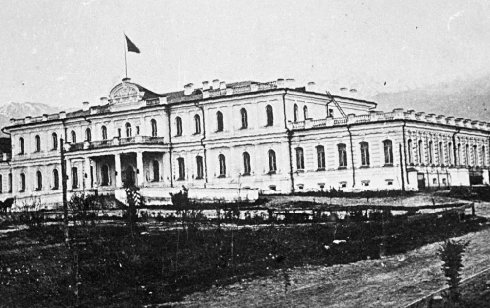
Governor-General's house. Verny. 1894/Wikipedia Commons
[Qalam]:
Chronologically, in writing about Almaty, especially in the Soviet or later publications in Russian, we often witness common assertions such as: ‘After the establishment of the Soviet power in the region, the city of Verny that was founded by the Cossacks in 1854, was renamed into Alma-Ata.’ It would have been preferable if, at the height of the Civil War, the workers and peasants who gained power had discarded the hated name of the Tsarist Cossack stanitsa Verny and bestowed upon the indigenous people a beautiful name in the Kazakh language: Alma-Ata, meaning ‘the Father of Apples’. Unfortunately, this is precisely the part of the city's history that many do not know, or they continue to perpetuate false conjectures. And that’s why we would like to squeeze in here and tell you a bit about the most myth-laden aspect of the city—its name.
First, when the independent Kazakhstan adopted its first constitution in 1993, as strange as that may sound, Alma-Ata was not renamed Almaty. Instead, the Kazakh name for the city, Almaty, became the official name in other languages, including Russian. So, on maps and globes, they started writing Almaty instead of Alma-Ata, and the Russian-language newspaper Vechernaya Alma-Ata was renamed Vecherny Almaty.
Moreover, the city has never been called Alma-Ata in Kazakh, neither in 1991 nor in 1921, when it was renamed from Verny. The order of the Semirechensk Regional Revolutionary Committee on 3 February 1921, stated: 'Henceforth, the city of Verny will be called, in the language of the working people, Alma-Ata.' Since at that time, the ‘language of the working people’ meant Russian, the name change did not affect the Kazakh language. So, in any publication in Kazakh, even the most ideological ones, such as the Kazakhstan Communist magazine (Қазақстан коммунисі), you would have certainly come across ‘Almaty’, not ‘Alma-Ata’, such as in the Almaty Regional Committee of the Communist Party of Kazakhstan (Қазақстан Компартиясы Алматы облыстық комитеті).
Why the Semirechensk Regional Revolutionary Committee suddenly decided that Almaty, unlike Tashkent, was not sufficiently Soviet, while the pseudo-Kazakh Alma-Ata, this grandfather with a female name, was deemed appropriate remains unclear. This was an odd turn of events given that the similar-sounding Auliye-Ata (modern Taraz) did not suit them. Consequently, it was swiftly renamed Mirzoyan, and after Mirzoyan's execution, it was renamed to Jambul (Жамбыл in Kazakh).
Second, Almaty was never Verny for the Kazakhs. Open any encyclopedia, geographical handbook, or pre-revolutionary travel notes, and you'll encounter the following: ‘Verny is known as Almaty among the Kyrgyz’; or ‘The locals also refer to Verny fortification as to Almaty’; or ‘The solid foundation of horticulture was laid soon after the occupation of the region (in 1856) with the establishment of the government garden in Verny, known to the savage locals as Almaty, i.e., Apple City.’ Now, let's take a look what Semenov-Tian-Shansky himself had to say: ‘Continuing my journey beyond the Ili River, I crossed it and, at the end of August, arrived in the Trans-Ili region, to the Verny fortification, or the city of Almaty, as the locals call it—thus, in the farthest Russian settlement in Central Asia.’
Here, one might think that the names were all binary, clear, and straightforward: the Russians called the city Verny and Kazakhs called it Almaty. However, it's not quite that simple. Back then, Russians often called the city Almaty despite its ideologically fitting and Russian name, Verny. Semenov-Tian-Shansky signed his famous letter to the Imperial Russian Geographical Society as being sent from ‘Almaty, or the Verny fortification’. An article on Verny in the Brockhaus and Efron Encyclopedic Dictionary states that ‘the locals, and partly the Russians, often call Verny by its old name Almaty’. The military-statistical compilation Turkestan Krai uses almost the same statement: ‘The locals and many Russians call Verny by its old name, Almaty.’
The Latinized version of the city's name, Almaty, appears in the writings of European authors and travelers, many of whom chose to use its former name rather than Verny.
'I was born on the shores of Lake Issyk-Kul, not far from the city of Almaty (dans les environs de la ville d'Almaty),' wrote Leon Cahun in the first page of his book La Bannière Bleue (1877), and the Encyclopaedia Britannica presents 'Vernyi' as the current name for Almaty.
Of course, the name Almaty is mentioned and used even before Russian conquest, occasionally appearing as 'Almatе' in Alexander von Humboldt's travel journals of 1829. However, it surfaces more frequently in chronicles and records as ‘Almatu’, somewhat resembling a Mongolian style, particularly reminiscent of how ‘Batu’ transformed into ‘Batiy’. The mention of Almaty literally opens the Baburnama, the memoirs of Zahir-ud-din Muhammad Babur, the founder of the Mughal Empire. In the Tarikh-i Rashidi by Muhammad Haidar, ‘Almatu’ is one of the most significant places in Moghulistan, which would later be conquered by Amir Timur. No one had any doubt that modern-day Almaty, just like the Verny fortification, is located ‘on the spot where the city of Almaty existed in medieval times,’ since ‘now it is quite verified that the current city of Verny, located between the rivers Ili and Chu, on the Ili tributary, was built on the site called Almaty (Almatu)’. Everyone knew about the ruins of the ancient settlement and the irrigation ditches: the locals, the newcomers, and even the Russian ethnographer Nikolai Abramov. Writing about it, Abramov stated that ‘the Russians, who came to Verny to establish the fortification, found millstones left here on the bank of the Almatinka River. One can see the ruins of an ancient fortification, where the Talgar River starts running from the mountains. The Kyrgyz attribute it to the time of Khan Tokhtamysh.’
Road to Medeu / Wikipedia Commons
Dennis Keen:
One way to recenter a native understanding of Almaty is to recenter its geography. Today, Almaty’s central district is known as the Golden Quarter, a neighborhood of mostly Soviet-era landmarks that is more or less coterminous with the original Tsarist-era grid of the city, then known as Verny. The 1870s master plan of Verny laid out a city of right angles and arrow-straight avenues, typical of garrison outposts, between the Vesnovka and Malaya Almatinka rivers. With time, settlers (mostly Slavic but also Tatar, Uighur, and Dungan) developed this grid into a bustling, provincial capital.
Native Kazakhs, however, lived mostly outside the rectangular blocks of Verny. Some well-off nomads, like Medeu, kept a home in town, but most would have maintained their tradition of transhumance, vertically migrating between the mountains and steppe. The closest thing nomads had to permanent settlements were their winter quarters, qystau, where simple adobe huts, or jer üi, would have created the semblance of a village.
Constructionist Alma-Ata
Anna Bronovitskaya:
When Almaty was made the capital of the Kazakh Autonomous Socialist Soviet Republic (ASSR) within the Russian Soviet Federative Socialist Republic (RSFSR) in 1929, the ethnic Kazakhs constituted a relatively small minority among the city's residents. The share of the Kazakh population rose from 6 per cent in 1913 to 24 per cent in 1935 mainly as a result of the ‘planned settlement’ program implemented when nomads, deprived of the opportunity to maintain their traditional way of life, sought refuge from starvation in various cities in Kazakhstan, including Almaty. However, even without them, the city began to grow rapidly. In 1930, the Turkestan-Siberian Railway connected Almaty to Tashkent, Semipalatinsk, and Moscow, and from that moment on, it became an important node in the economic plans of the Union of Soviet Socialist Republics (USSR).
At the beginning of 1929, Almaty had a population of 55,000, and by 1935, it had already reached 190,000, with the majority of the residents coming from great distances. In 1930, a feverish level of construction began, but the population was growing faster than the housing available. In 1931, there was only 3.1 square meters of residential space per resident. Thus, the city authorities were forced to allow spontaneous development on the outskirts. As a result, Almaty developed a significant 'private sector' that continued to exist through the Soviet period. But along with this, within a few years, a significant wave of constructivist architecture emerged, befitting the city's newfound status as a capital. However, most of it was designed in Moscow.
In 1932, Almaty received a new general plan developed by the Giprogor Russian Institute of Urbanism and Investment Development in Moscow. According to this plan, industrial development was being planned north of Tashkent Alley, while the residential parts had mainly retained their previous structure. The street previously known as Starokladbishchenskaya Street, renamed Vokzalnaya in 1930 and Stalin Avenue in 1933 (further renamed Communist Avenue from 1961 and now known as Ablai Khan Avenue) became the city's main thoroughfare. This street began at the Alma-Ata 2 Station and ran past the former Cossack Square, which, in 1928, was designated as the city's main square and was named accordingly—Krasnaya (meaning red), later renamed Lenin Square and now Astana Square. When the city was known as Verny, this square was a parade ground lined with barracks. Since the early 1930s, it has become a square with flower beds with key administrative structures lining its perimeter. These include Government House (1927–31) and the Turkestan–Siberia Railway Administration Building (1928–30), designed by the prominent constructivist architect and theorist Moisei Ginzburg, along with his co-author Ignatijus Milinis, who were known for the internationally renowned Narkomfin Building and the Telegraph Building, which was located on the site of the former Military Cathedral. In the early 1930s, they also built the Exemplary Canteen of Kazkraisoyuz, the TurkSib town near the Alma-Ata 1 Station, and the complex of buildings of the NKVD on Dzerzhinsky Street (now Nauryzbai Batyr Street).
Unfortunately, a large part of the constructivist heritage has reached us in a greatly dilapidated form, and much of it has been completely lost. It quickly ceased to be appreciated due to changes in the all-union cultural policy in the early 1930s. The book on the architecture of Almaty, published in 1950, states the following: ‘All these structures [Government House, Communications House, TurkSib Administration] are endowed with elements of asceticism and simplification; they completely lack architectural plasticity and the artistic decor beloved by the Russian people and the peoples of the Eastern republics. The architecture of these buildings bears the traits of formalism that are not characteristic of the artistic traditions of the Soviet Union.’ In the 1930s, the TurkSib Administration building underwent a transformation to mimic classical architecture, compromising its artistic integrity. Meanwhile, other constructivist structures were deemed unworthy of meticulous preservation and were reconstructed to suit contemporary requirements without regard for their historical significance. The global recognition that constructivism achieved in the 1970s had yet to have an impact on the fate of the constructivist heritage in Almaty.
Meanwhile, the former Government House, which now houses the Temirbek Jurgenov Kazakh National Academy of Arts, is an outstanding monument of constructivism that can still be restored to its original form. The caliber of Moisei Ginzburg's work is demonstrated by its victory in a nationwide competition in which prominent architects such as Ivan Leonidov, Pavel Blokhin, and others also participated.
Alma-Ata in Socialist Realism
Anna Bronovitskaya:
From the mid-1930s, all Soviet architecture was required to adhere to the only correct method: socialist realism. While it was somewhat clear in relation to literature, cinema, or even painting that this meant a realistic portrayal of life not as it is but as it appears in the context of building socialism, numerous discussions on socialist realism in architecture did not lead to any clear conclusions. However, some guiding principles emerged: 'the critical assimilation of the classical heritage' and 'socialist in content, national in form'. Essentially, this meant a return to the historicism of the second half of the nineteenth century, skillfully combining new functions with classical compositions and appropriate decorative styles.
The Soviet architecture of the 1930s to 1950s is commonly referred to as ‘Stalinist’ and frequently criticized for its association with totalitarianism. However, while there is no doubt that the sharp turn from international modernism to historical stylizations was dictated from the top, the architecture of this period in Almaty does not oppress but rather appears human and cozy. Due to seismic risks in the region, most buildings are three to four stories tall, occasionally featuring a tower at the corner. They follow the layout of the historical street grid, with some buildings deviating from the building line to form ceremonial courtyards known as 'cour d'honneur' (court of honor).
In 1936, the status of Almaty was elevated due to the formation of the Kazakh Soviet Socialist Republic (SSR). A year later, a new master plan, developed by Architectural and Planning Workshop No. 1 of the People's Commissariat of the USSR, was adopted. It followed the prevalent urban planning theory of the 1930s, which called for the enlargement of city blocks. Certain streets were transformed into pedestrian boulevards, intra-block areas were cleared, greened, and improved. Water supply and sewage systems were fully operational, and a tram line was established. The growth of the city was primarily planned to the west of the Vesnovka River (Esentai River). The foothills north of Alma-Ata were allocated as a recreational zone, where sanatoriums and vacation homes were built.
As the Government House, designed by Ginzburg and Milinis, began to seem ‘in no way suitable for a government building’, it was decided that a new one should be constructed on the other side of Lenin Square. The design for this Government House was developed in Leningrad (now St. Petersburg), but it turned out to be too monumental and rigidly classical for the Kazakh capital. It also distinguished itself in terms of scale, as no expense was spared in constructing earthquake-resistant structures for such a crucial building.
The 'national form' was typically limited to generalized orientalist decorative motifs overlaid on a classical foundation. This is evident, for example, in the building of the State Academic Theater of Opera and Ballet. The theater's layout effectively demonstrates the important concept of an ensemble in urban planning from the 1930s to the 1950s. ‘Against the backdrop of the snow-capped mountains of the Trans-Ili Alatau mountains and the surrounding greenery, the powerful volume of the theater stands out clearly. A wide staircase leading to a low stylobate adorned with parterre greenery, an improved square with a monumental statue of Comrade Stalin—all of these elements combine to create an interesting and complete ensemble.’
The planned construction in the post-war decade resulted in the Main Building of the Academy of Sciences of the Kazakh SSR (designed by the architects Alexey Shchusev and Nikolai Prostakov and built between 1948 and 1953) established in 1946. The renowned Soviet architect Shchusev successfully combined the symmetrical layout of a classical palace with motifs from the facades of madrasas, which he had studied in Bukhara and Samarkand in the late nineteenth century, along with incorporating Kazakh ornamentation.
During the Second World War, along with Tashkent, Almaty became a major center for the evacuation from the European part of the USSR. Dozens of enterprises were hastily relocated to the city and its surroundings, disregarding the master plan. The Kazakh capital emerged as a powerful industrial and intellectual center in the post-war period, but it suffered from infrastructural problems and a severe housing crisis. However, the eventual departure of evacuees did not halt the growth of the population as the newly built factories and plants required a workforce. Almaty also provided shelter for people who were released from the massive Gulag camps in Kazakhstan after Stalin's death—many political prisoners had nowhere else to go. The campaign to develop virgin lands that began in 1954 did not deter residents from coming into the city—on the contrary, it only increased their numbers. Many settlers, having completed their obligatory work on the land, sought to establish themselves in a city with a good climate. According to the 1959 census, the population of Almaty reached 456,000 people, twice as much as in the pre-war year of 1939 (220,000).
Alma-Ata in Kunaev Era
Anna Bronovitskaya:
In the mid-1950s, a large shift occurred in Soviet architecture. After the death of Stalin, Nikita Khrushchev came to power and initiated not only a campaign against the ‘excesses in architecture' but also a transition to industrialized housing construction. The main goal was to quickly provide each Soviet family with a separate apartment, but this also allowed architects to return to the path of international development and create modern architecture rather than stylized designs from the past.The city needed not just modifications to its pre-war plan but a fundamentally new master plan. From 1960 to 1963, the Leningrad Institute for City Planning and Design, the Lengiprogor, worked on the General Plan, which envisioned a projected population growth to 750,000 people by 1980 along with sharp limitations on the development of industry and other urban factors.
The Leningrad plan, which called for a decisive restructuring of the city's existing structure in a modernist manner, was officially approved but faced sabotage in reality. The architects of the mid-1960s were primarily focused on practical tasks such as the utilization of new materials and construction methods, the development of earthquake-resistant structures that allowed for buildings taller than three floors, and the creation of layouts that facilitated living in a hot climate without artificial air conditioning.
In 1967, following the construction of the mudslide protection dam in the Medeo gorge, which seemed to remove one of the main threats looming over the city, a nationwide competition was held for the reconstruction plan of the city center. The winning project was submitted by a group of planners from the Almaty design institute KazGorStroyProekt led by Nikolay Ripinsky. This project—which envisioned the preservation of the traditional grid of the city’s blocks, the expansion of the city in the western direction, the development of a system of local centers along Abay Avenue, and the creation of a green corridor with a recreational area along the Vesnovka River—served as the basis for the placement of new construction projects in Almaty.
This approach ensured the organic integration of new buildings into the existing urban fabric. For example, the buildings constructed in the late 1960s, such as the Scientific Research Institute on Shevchenko Street, were designed to form a square with a monument to Shoqan Walikhanov, facing the main building of the Academy of Sciences. By 1971, the Moscow Central Research Institute of Urban Planning, together with another local institute called Almaatagiprogorm, developed the technical and economic foundations of the master plan for Almaty, further developing Ripinsky's ideas.
Giprogor Building/Yuri Palmin
According to this plan, which was approved in 1978, the construction of new, large residential districts was already underway. The General Plan, which was designed with the perspective of being in use until 1994, envisioned a city with a dynamically developing center that stretched from north to south, from the Alma-Ata 2 Station to the foothills of the Trans-Ili Alatau Mountains, extending slightly east of Abay Square and expanding in the western direction, encompassing suburban lands.
In terms of the architecture of Almaty, the period from the 1960s to the 1980s was a time of true flourishing. The city saw the construction of numerous vibrant structures, and they were now being designed locally, although major projects still required approval from Moscow. Much of this became possible thanks to the thoughtful policies of Dinmukhamed Kunayev, the First Secretary of the Kazakhstan Communist Party from 1960 to 1962 and from 1964 to 1986. In 1972, the celebration of the fiftieth anniversary of the formation of the USSR drew attention to each of the republics, leading to a kind of competition between capitals, including in the field of architecture. Almaty was fortunate in that the Kazakh leader not only had significant ambitions but also had a knowledge of architecture. He consistently supported good projects and, moreover, was a personal friend of Leonid Brezhnev, who became the General Secretary of the Central Committee of the Communist Party of the Soviet Union (CPSU) in 1964. Kunayev utilized this friendship to promote particularly unconventional solutions and secure financing from the center when necessary.
Kunayev developed Almaty as a modern international city while also addressing the critical ethnic and cultural imbalances in the republic. According to the 1970 census, Kazakhs accounted for only 32 per cent of the population in Kazakhstan. While architectural education was being reformed within the republic itself, capable young Kazakh men and women studied in Moscow and Leningrad before returning home to apply their knowledge in practice. They entered a highly creative environment, led informally by Nikolay Ripinsky, who had received his education during the avant-garde era, graduating from the architectural department of the Kyiv Institute of Civil Engineering in 1931. In 1949, Ripinsky was repressed on charges of cosmopolitanism and served his sentence in Kazakhstan. Upon his release in 1954, he decided to settle in Almaty.
When the need arose to create modern architecture again, Ripinsky was practically the only one who understood how it should be done. As the chief architect of KazGor, the main design institute in the republic, Ripinsky gathered a talented group of young architects. In 1960, when he attended a meeting in Moscow on the creative direction of Soviet architecture, he urged his colleagues to come and work in Kazakhstan. He said, ‘There are only 100 architects in Kazakhstan. This is very few. I cannot help but invite my fellow architects to this “virgin land.” Come, and you won't regret it.’ Later, Kunayev's envoys recruited the best graduates of architectural universities in Moscow, Leningrad, Novosibirsk, and Odessa, promising them decent living conditions in Almaty and the opportunity for prompt project implementation.
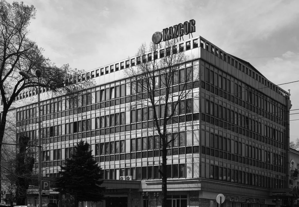
Kazgor / Yuri Palmin
The team assembled by Ripinsky created the main symbol of Soviet Almaty, the Palace of Lenin (now known as the Palace of Republic). The golden roof soaring above the rectangular volume of the building, measuring 100 meters in length, is not simply a striking image. It is supported by separate supports rather than walls, and a self-supporting lattice structure allowed for spanning a distance of 76 meters above the main hall. Traditional construction methods would not have been possible to build a 10-meter-high hall capable of accommodating 3,000 people with glass walls in a seismic zone. This building clearly emphasizes Kazakh motives, not by any ornaments but thanks to the curvature of the roof. The building featured elements referencing the canopy of a Kazakh yurt, and the kalpak (a Turkic felt hat with folded brims), and the ancient monuments of Mangyshlak (Mangystau).
Unfortunately, the fame of the Lenin Palace during Soviet times led to a desire to modernize it in independent Kazakhstan. However, following its reconstruction in 2010, it is difficult to look at the palace, after it was ruined with the addition of plastic windows and reflective glasses, without a sense of sorrow. However, many other structures constructed by Almaty architects from the 1960s to the 1980s have been preserved, and these are remarkable for their originality and diversity. Many of them are located along Lenin Avenue (now Dostyk Avenue), the main urban axis and architectural showcase of Almaty during this period. Next to the Palace of the Republic stands the Arman Cinema, which abandoned national ornaments in favor of epic reliefs by the sculptor Victor Konstantinov. The regional specificity is reflected in the volume of the cinema, which is turned outward with solid walls while it hides a cozy courtyard, a summer open-air foyer, inside. On the other side of the palace, the first skyscraper in Almaty rises, the twenty-five-story Hotel Kazakhstan, all at once a triumph of seismic-resistant construction and a striking image. By the late 1970s, strict geometry had gone out of fashion, and architects had allowed themselves to top the hotel building with a golden ‘crown’. Such overt embellishment caused some scandal and consternation at the time, but now one can only rejoice at its instantly recognizable silhouette.
During the same years, the Park of 28 Panfilov Guardsmen in Almaty saw the construction of the Officers' Circle House (now the Army House of the Republic of Kazakhstan). This impressive structure took a further step away from modernism toward postmodernism. The architects interpreted the imperial grandeur of Karl Rossi's creations in St. Petersburg, both in the exterior architecture with its multi-columned arcade and in the interior, in their own way. The grand three-story foyer, adorned with chandeliers shaped like aerial bombs and a gallery railing reminiscent of tank armor, was also intended to serve the Operetta Theater, which was designed as part of the Officers' Circle House complex. However, the theater was never realized, and the unique surrealist interior remained unknown to the general public.
At the international level, the Medeo Ice Stadium became synonymous with Almaty. It hosted major competitions and set numerous world records. This high-tech facility with its artificial ice, designed to seat 10,000 spectators during competitions and 2,500 skaters on regular days, blends in perfectly with the natural surroundings of the city. However, it is not entirely natural. Directly above the stadium is a massive mudslide protection dam.
In the summer of 1963, when a mudslide practically destroyed Lake Issyk, a favorite recreation spot for the city's residents, it became clear that urgent action was needed. A year later, a project to block the Medeo Gorge using directed explosions was completed. ‘The 147-meter pyramid of Cheops was built by 100,000 slaves over the course of a whole generation. The dam in Medeo, comparable in volume to the pyramid of Cheops, was created by an explosion in a matter of seconds,’ the newspapers wrote about this extraordinary structure in 1967. However, it was not possible to foresee every detail accurately from the outset. The water drainage filters became clogged, and in the summer of 1973, heroic efforts were needed to prevent the water and mud that had filled the teletransmitter from crashing down on the recently opened stadium and the city. But the initial mistakes were corrected, and the city has been reliably protected from mudflows ever since.
Dennis Keen:
Let’s dwell here a little bit on ‘Medeo’, or ‘Medeu’, to be more exact. High in the mountains above Almaty is the city’s pride and joy, the Medeu Arena, the highest ice-skating rink in the world. This huge and unique open-air arena was inaugurated in 1972 as an instant-classic Socialist Modernism set amidst a scenic alpine backdrop, a concrete complex of hotel rooms, box seats, and bandstands surrounding a 10,500-square-meter ice field. Medeu’s ice was legendary, frozen with such technical sophistication from pure mountain water that it could be skated upon with stunning speed, and the arena became known as the 'factory of world records' for speed skating. To this day, tourists from the Netherlands, a nation of speed-skating fanatics, make pilgrimages to touch the frozen course of champions.
30 kilometers away to the northwest of the city in Ile County, an ancestral Kazakh cemetery regularly receives an altogether different kind of pilgrim. Women in headscarves come to touch the granite headstone of Medeu Pusyrmanly, the Kazakh nomad who gave the Soviet stadium its name. It was his family’s jailau, or summer pasture, that became the site of the Medeu Arena, and his qystau, or winter camp, was here in the steppe along the banks of the Big Almaty River. This is a fact known to only a few Almatians, the rest of whom associate the word ‘Medeu’ with winter recreation rather than a local patriarch. This historical figure has been reduced to a toponym, but he and his tribesmen buried in this overgrown cemetery were the original, native Almatians.
These days, while exploring the heritage of historical sites as ancestral cemeteries and the memories of local tribe members, we can demonstrate that the primary Kazakh settlement in the Almaty area was located in a place now known as Pervomaisky. To the twenty-first-century cohort of 'korennye almatinsy' (native Almatians), this assertion might sound surprising and perhaps even absurd. Pervomaisky (a toponym meaning May the First, named for International Labor Day) is a sleepy suburb known for Pervomaiskie Ozera, a collection of small recreational ponds. The reed-lined reservoirs were created during the nineteenth century by damming the Big Almaty River. In the Tsarist era, they were known as the Priyutskie Ozery, or Orphanage Lakes, after a shelter built nearby by members of the Russian Orthodox community. Pervomaisky today is better known for its mosquitoes and jet skis, a remote hamlet on Almaty’s outskirts that few city dwellers think about until it is time to escape to its waters in the summer heat.
There is reason to believe, however, that Pervomaisky would have been an important center for the nomadic tribes of Almaty in the nineteenth century. Medeu Pursumanuly's official address was in a village near Pervomaisky known as Aul #3, which later became the settlement of Japek. Medeu's son Zhaishibek left his own mark on the area, building an aryk, or irrigation canal, from Zhapek to the village of Zhetigen. Medeu's other son, Aidarbek, grew a grove of trees in an adjacent settlement known as Ashisai or Vinsovkhoz, and Medeu's cousin Bedelbai planted and grew an apple orchard on almost 15 hectares of land in Japek. The ancestral cemetery where Medeu and his family are buried, belonging to the Bolai clan of the Shapyrashty tribe, is on a plot of land between Japek and Tuimebaev.
Another 3 kilometers to the west was Aul #2, now known as the village of Komsomol. This place was home to other famous nineteenth-century Kazakh Almatians from another clan, the Qasqarau of the Dulat tribe, including Ibragim Jainakov (1883–1947), an influential local leader in the Alash Orda movement for Kazakh political autonomy, and his father, Jainak Karatalov (1816–1905), a powerful chief of the Baba-Kaskarau volost. For generations, the Qasqarau migrated throughout a vast area that stretched from Kordai (to the southwest near the Kyrgyz border) to Kapal (to the northeast near the Jungar Alatau), but by the second half of the nineteenth century, their traditional nomadic migration routes were likely blocked by Russian settlers, and they were forced to make the Pervomaisky region their headquarters. By 1882, records show that Jainak Karatalov lived here with 3 households, 6 men and 4 women, maintaining 15 camels, 100 horses, 5 cows, and 1,000 sheep.
While wealthy nomads like Jainak Karatalov and Medeu Pusyrmanuly lived with their families near the ponds of Pervomaisky, they sent their sons to the city to study in the first colonial school for Kazakh children, the Verny Gymnasium for Boys. Jainak’s son Ibraim would study there, as would another local Alash activist, Tölembai Düisebaiuly (1884–1937). These people, despite being some of the most powerful and well-known Kazakh Almatians of their time, have now faded into obscurity, their contributions nearly erased by the anti-Alash prejudice of Soviet historiography. Now, their names are known to mostly tribal historians, but they once formed a kind of native gentry who would have had an important impact on the early social and economic affairs of Verny.
Almaty

Bayken mosque / Alamy
Anna Bronovitskaya:
In 1991, the city became the capital of the independent Republic of Kazakhstan, and this status was retained until 1997. In 1993, Almaty, its original Kazakh name, was officially adopted for use in other languages. The architectural ensemble of the New Square, constructed in the 1970s, lost its status as the building that housed the Central Committee of the Communist Party of the Kazakh SSR in the last decade of the Soviet era, and it was taken over by the Akimat (city administration).
Almaty remains the largest city in Kazakhstan, home to just over a million people in 1991 and approximately two million now. It is a significant scientific and cultural center, but the government's relocation to Astana means a much more modest budget for development and urban improvement. As a result, there have been relatively few notable examples of vibrant contemporary architecture in Almaty. One exception is the multifunctional complex of the Esentai Park, designed by the renowned American architectural firm SOM and built to very high international standards. Another achievement is the launch of the first phase of the metro system in 2011. However, uncontrolled growth, poorly planned development of the mountain countertops, and a sharp increase in the number of cars have led to serious environmental problems that have yet to be addressed, as well as challenges in road safety.
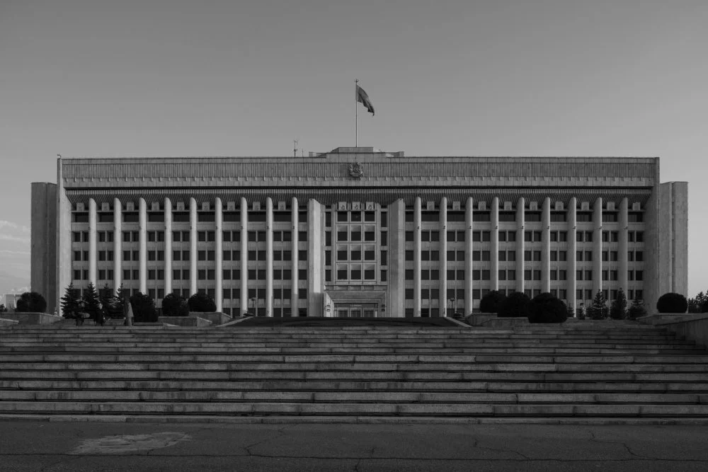
Akimat building. Almaty/Yuri Palmin
One of Almaty's strengths, in contrast to Astana, lies in its self-awareness as a historical city. Its relatively recent past holds significant value. After a series of unsuccessful reconstructions of Soviet-era buildings, there have been recent examples of the careful preservation and restoration of this architectural heritage. For instance, the modernist Almaty Hotel was delicately renovated in 2017 by the British firm Chapman Taylor. The reconstruction project of the Almaty Television Center sparked intense public discussions, leading to a decision in 2019 that preserved the building's external appearance, resembling a magical box from an Eastern fairy tale.
Dennis Keen:
The history of Almaty and its environs is punctuated by a sequence of renaming events that transpired during the imperial and Soviet eras, a practice that persists in the present day. During the Tsarist regime, the local Kazakh elite would winter in the vicinity of Pervomaisky while conducting their studies and business affairs in Verny. However, during the summer, they would retreat to the Alatau Mountains, which stand majestically above these settlements on the steppe. Just like Medeu, which has emerged as one of Almaty's most renowned toponyms, the names of these influential nomads were once used to designate geographical landmarks in the foothills of the Alatau. Subsequently, most of these places received Russian toponyms from the colonial settlers, which remain commonly used today. Rediscovering Almaty's ancestral place names offers an opportunity to delve into the rich history of the native Almatians who called this region home for centuries.
On the other hand, Kök Jailau, a popular hiking destination for Almatians and tourists alike, is an interesting case. The name seems to be pre-colonial, as it means 'green summer pasture' in Kazakh, but it is apparently a modern invention. Marat Alishev, an inspector for the Big Almaty Forestry, claims that the name 'Kök Jailau' arose only around the 1980s. Alishev's ancestors once spent their winters in Pervomaisky and their summers in these Alatau valleys, and they called this picturesque pasture Teris Butak Saiy, or the Valley of Crooked Bushes. Kök Jailau is filled with campers and their families on weekends, but it would have been full of yurts until the collectivization campaign of the 1930s, the last mountain home of Alishev’s family.
The names of Alishev's ancestors are spread throughout these mountains. Some are obscure, known only to local shepherds—gorges known as Tobylqy Sai, Meirman Sai, or Muzdybai Sai. The word sai in Kazakh is used to describe streams and the narrow valleys around them. A small river, now known by the Russian name Batareyka, was once called Bedelbai in honor of a cousin of Medeu, while Butakovka—a popular route to the waterfall near Bedelbai's groves—was known by the name of Bokenbay, another of Medeu’s relatives.
Butakovka has resisted an official change of name, but another prominent Almaty river, still known to many locals as Vesnovka, has been officially renamed Esentai. Now also the name of an adjacent luxury mall and housing development project, Esentai too gets its name from a famous nomad.
The names of some places have questionable origins, such as the Soviet dacha district Yermensay, where the current elite of Almaty are building their mansions. Some names have disputed origins, like Alyoshkin Most, also known as Alyosha’s Bridge, located in the Prokhodnaya Gorge within the Ile-Alatau National Park, renowned for its Alma-Arasan hot springs. Popular legend attributes the name to a hiker, Aleksei ‘Alyosha’ Molchanov, who tragically drowned here in 1987, and a commemorative plaque at the site attests to this etymology. But trekkers who have spent time in the Prokhodnaya Gorge in the 1970s say that it was known as Alyoshkin Gorge even then. Marat Alishev claims that the place’s original name in Kazakh was Alishtin Köpiri, meaning the Bridge of Alish, the forester’s paternal grandfather.
Some commentators argue that studying and restoring old names of places is a distraction from more pressing economic and social concerns. But as we can see from these examples, learning these older, indigenous names allows us to reconstruct the family trees of those who lived here and reassert their place in a local history that’s largely been written by settlers and their descendants. Using ancestral toponyms is a way to honor the contributions of native Almatians like Bedelbai Kuzumbaiuly who contributed to the beautification and development of the city. Restoring the usage of pre-colonial place names is a way to commemorate a time when these lands were treated with reverence and touched only by the light hand of nomadic pastoralism, a marked contrast to today, when people have lost a meaningful connection with the land they live on and thus treat it with indifference.
Indeed, it could be argued that many of the ills of urban life in Kazakhstan—the inhumane housing developments, the roadside litter and industrial pollution, the haphazard infrastructure—result from a profound lack of emotional connection to the land. The trauma of collectivization, in which millions of Kazakhs were forever torn from their ancestral lands and deprived of their traditional way of life, resulted in generations of city dwellers who have no meaningful historic connection to the urban environment.
There is no going back to this window-less world. In Kazakhstan, there is no back-to-the-land movement, no mass migration to jailaus, no city dwellers selling their flats and moving into yurts. The next best thing, it seems, is to keep the land in our memories, to use the power of our imaginations to ground history in our everyday surroundings. This is the power of place names, like Medeu, which can bring to mind the man with a mere mention. If these memories can be kept alive, they can serve as a source of meaning for an uprooted population and as a fertilizer for old identities to take root once again.