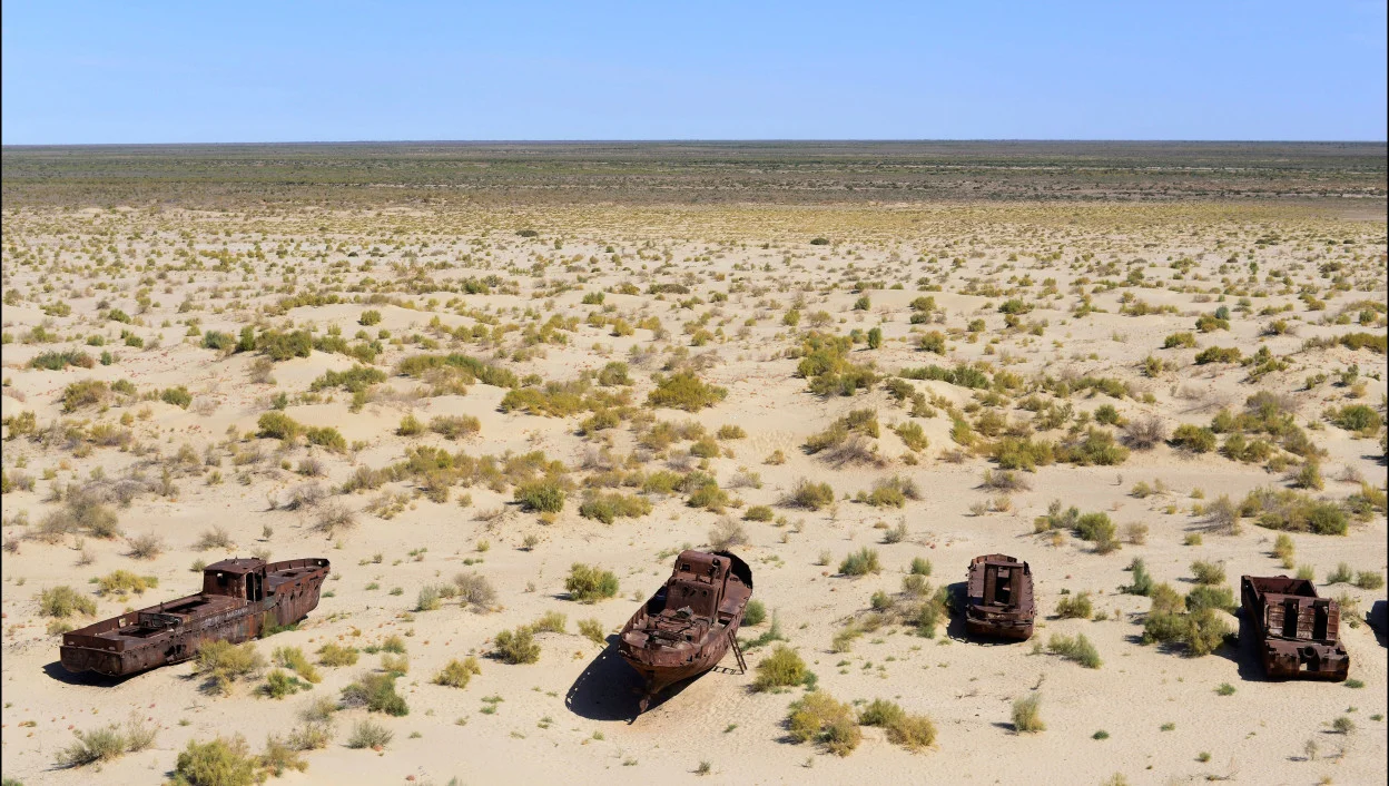
Rusty boats lay still on the dry desert sea bed of the dried Aral sea/Alamy
The well-known project of reversing Siberian rivers to irrigate the arid regions of Central Asia now seems to many as insane and unfeasible as the hundred-storey Palace of the Soviets in Moscow, growing corn in the polar regions, or apple trees on Mars—simply another example of totalitarian megalomania. However, this project of transforming nature on a continental scale is not unique. In fact, in some places a similar plan is being implemented right now.
Let me start by talking about what the river reversal project was about and why the Soviet leadership needed it. First, they wanted to irrigate the arid regions of Central Asia and second, they wanted to create a waterway between the different regions of the country.
It is worth noting that the first recorded scientific (kind of) work on the topic of climate mitigation, involving the transfer of river runoff from Siberia to Central Asia, was the work of Yakov Demchenko, a student of the final class of the Kyiv Gymnasium No. 1, a future public figure, and publicist of monarchist persuasion. The article appeared in 1868, and in 1871, he published a book on the same subject titled On the Flooding of the Aral-Caspian Lowlands to Improve the Climate of the Adjacent Countries, with the second edition published in 1900.
Yakov Demchenko rightly pointed out that the Aral-Caspian lowland was once (about 2 million years ago) occupied by a sea connected to the rivers of Siberia. Thus, if part of the flow of the Ob and/or Irtysh to the Aral Sea was transferred, a huge body of water connecting the Caspian and Aral Seas would appear (or rather, would be restored), the influence of which ‘on the climate of the neighboring countries would be very large and multilateral’. The idea did not go further than a book, and when it was revived in 1948 and presented to Stalin, he was not very enthusiastic about it either.1 1You can read Yakov Demchenko’s work in its entirety on the website of the State Public Historical Library of Russia.
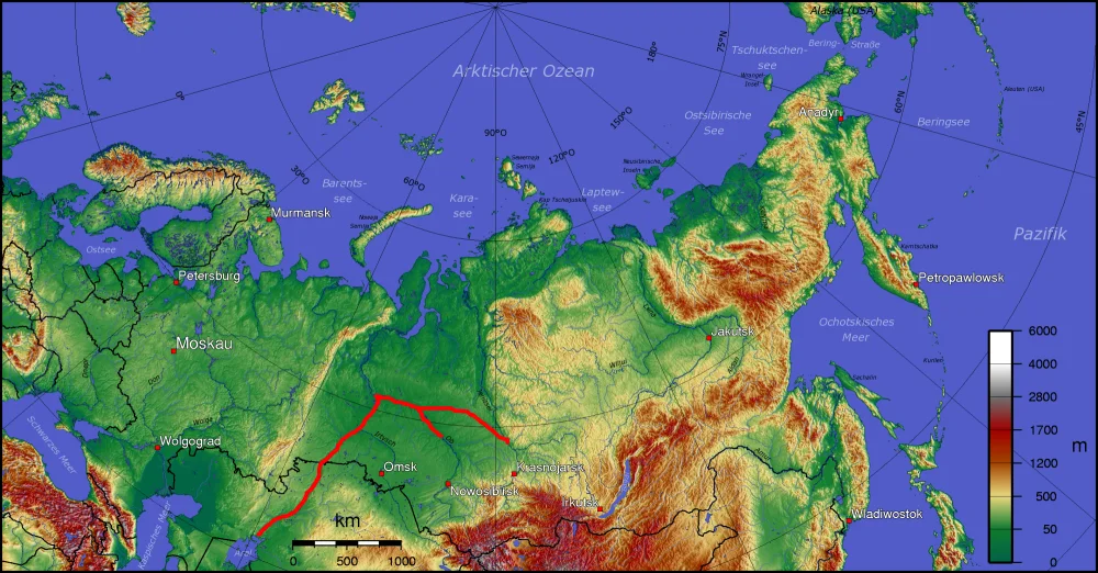
One of the versions (probably, 1960s vintage) of the Russian Northern Rivers Diversion plan/Wikimedia commons
In the 1950s and ’60s, however, the idea became a project, not least because the water problem became much more acute as the consumption for irrigation increased in Kazakhstan and Uzbekistan. It should be mentioned that in the 1960s, due to the construction of irrigation canals and massive agricultural development, the flow of rivers feeding the Aral Sea radically decreased, leading to a fall in the level. Entire institutes worked on the project, and various plans and calculations were made. The idea was really grandiose—redirecting a part of the Ob River’s flow through a 2,500 km long canal to the Aral Sea, reversing the Irtysh, Tobol, and Ishim (Esil) rivers, creating a system of canals and reservoirs (including flooding the Turgai Valley), transporting fresh water to Kazakhstan, Uzbekistan, and Turkmenistan. Some versions of the plan included creating a navigation pathway through the channel leading from the Kara Sea to the Caspian Sea and further to the Persian Gulf. Earthworks using low-yield nuclear charges were also envisaged.
In 1968, the Irtysh-Karaganda Irrigation and Water Supply Canal was opened, which can be considered a part of the water supply system for the central part of Kazakhstan and the first element of the mega system. In 1970, the Central Committee of the Communist Party of the Soviet Union issued a resolution titled On Prospects of Development of Land Reclamation, Regulation and Redistribution of River Flows in 1971–1985. In 1978, another resolution was issued by the Central Committee of the Communist Party of the Soviet Union and the Council of Ministers, On Conducting Research and Design Work on the Problems of Transferring Part of the Flow of Northern and Siberian Rivers to the Southern Regions of the Country.
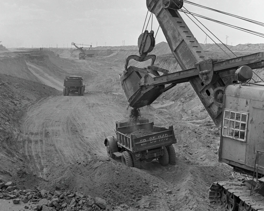
Building Irtysh–Karaganda Canal/РИА НОВОСТИ
By 1986, however, the project was over. The reasons for this were not limited to only the decline of the Soviet economy (the cost and complexity of the project were expected to be enormous) and the conflict of interest between the Soviet agencies involved. There was also the pressure of an information campaign by Soviet scientists about the monstrous environmental and social consequences of such a plan, which included the flooding of fertile lands and settlements by reservoirs, waterlogging of territories, death of ecosystems both downstream of the Ob and in Kazakhstan, et cetera. In the twenty-first century, the idea has been revived in both Russia and Kazakhstan, but no concrete steps have (yet) been taken to implement it.
WHAT’S WRONG WITH RIVER REVERSAL PROJECTS?
First, the estimated costs of such a project are alarmingly high. For example, sources suggest that the cost of a Siberia-Central Asia canal alone could be as much as 32.8 billion rubles. And that’s just for starters! Here is what Mikhail Nemtsev, a visiting researcher at the Russian Academy of National Economy and Public Administration (RANEPA) and associate professor at the Novosibirsk State University of Economics and Management, writes in his paper Toward the History of the Northern Rivers Reversal Project: ‘… Academician A. Aganbegyan presented data on the exact calculation of the construction costs, according to which the construction would require at least 100 billion rubles.’ In the 1970s and ’80s, Abel Aganbegyan was the deputy chairman of the Scientific Council of the Siberian Branch of the USSR Academy of Sciences, focusing on the integrated development of natural resources and the advancement of Siberia's productive forces, and his calculations, in all likelihood, were at the basis of the proposed budget. And let’s not forget that these were only the cost of construction—the budgets for the resettlement and relocation of flooded settlements with the restoration of infrastructure, housing, enterprise, and other things were not even considered. And let’s now compare these amounts with the Soviet budget: in 1970, the federal budget revenues amounted to 156.7 billion rubles and to 265.8 billion rubles in 1978.
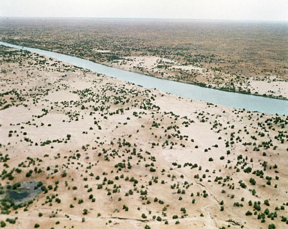
Karakum Canal/РИА Новости
Monstrous images, painted by opponents of the project from the ranks of Soviet science, of the environmental catastrophe that would inevitably follow the realization of these plans were widely known. In 1981, Alexander Yanshin, a geologist, vice-president of the Soviet Academy of Sciences, and head of the scientific expert commission ‘On Increasing the Efficiency of Soil Modification in Agriculture’, wrote to the Central Committee of the Communist Party of the Soviet Union about the Ob-Caspian Canal: ‘A 200-meter-wide trench will block the centuries-old migration routes of animals. This will lead to the extinction of the reindeer. Once the canal is operational, a severe water shortage will hit Altai, Russia’s breadbasket, the coal fields of Kuzbass, and the megacities of Novosibirsk and Omsk. The reduction of the flow of freshwater into the Arctic Ocean will increase its salinity, which means that the permafrost boundary in Russia will move fifty kilometers further south. The number of fish in all Siberian rivers will decrease sharply, and the dwindling populations of the indigenous peoples of the north will surely face starvation. The swamps of Western Siberia will begin to dry up, which means that peat fires will break out over a huge area and will be almost impossible to extinguish. The meadows will be flooded, the fodder base for cattle will be destroyed, cattle breeding as a type of economy in Siberia will gradually die out. The lands through which the ditch will pass will eventually turn into a marshy desert, including the most fertile areas of the Kulunda and Barabinsk steppes. More than two thousand settlements will sink to the bottom of the reservoirs. The historical center of Barnaul will be flooded, and an area equal to that of modern Germany will be underwater.’ It was a truly apocalyptic picture! In the near future we will probably not be able to confirm whether the academician and other critics of the project were right, but we can look at real examples of the realization of such plans and draw our conclusions by analogy.
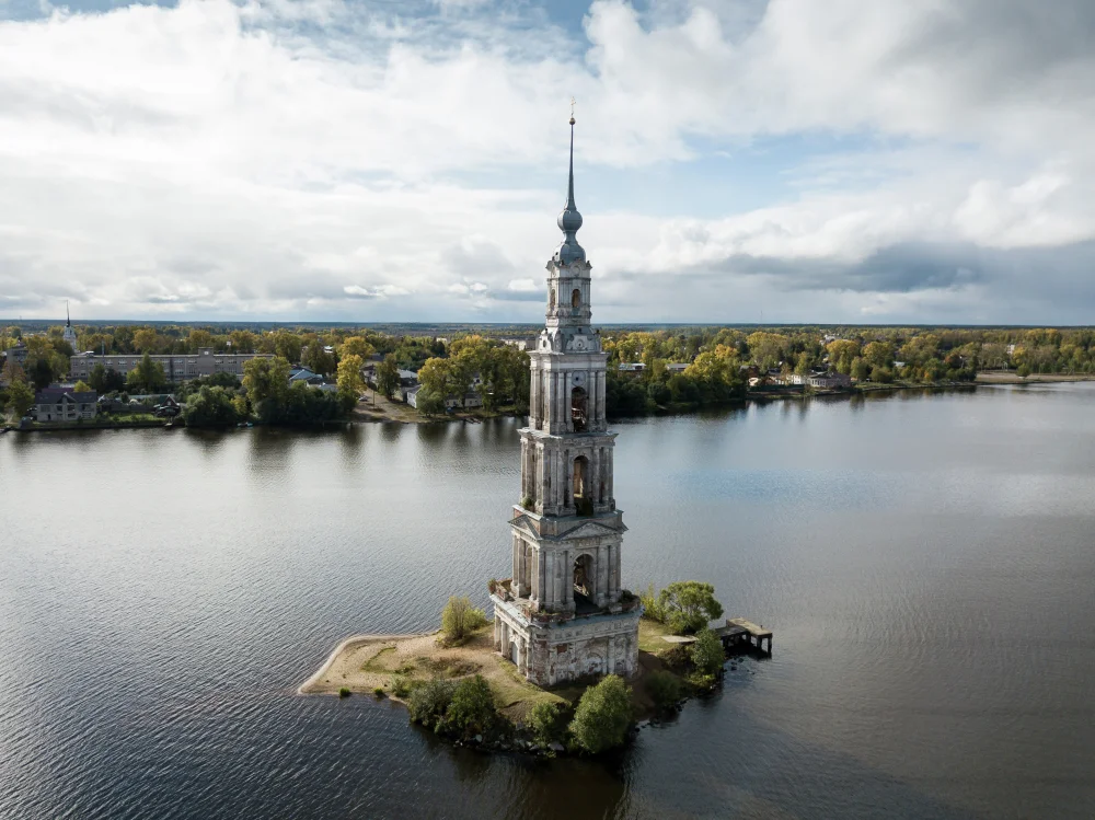
The historic town of Kalyazin, on the Volga, in the Tver region of the Russian Federation lost about two thirds of its area—the Uglich Reservoir swallowed the central and left bank parts of the town, and cultural monuments were destroyed. The bell tower of one of the demolished cathedrals, preserved as a lighthouse, became a symbol of the drowned town/РИА Новости
The construction of a cascade of reservoirs on the Volga, for example, has led to a number of undeniably negative consequences for the river and its surroundings. Due to the interruption of the normal flow in the various sections of the Volga, water pollution has increased, biodiversity has decreased, and the level of the Caspian Sea has fallen by 6–7 centimeters per year, causing concern in Iran, which is feeling the consequences of this phenomenon. And the reservoirs themselves are becoming shallower. The experience of creating reservoirs in Siberia is no better: it is not economically feasible to completely clear the flooded areas of forests. Additionally, after flooding forests, among other things, the oxygen content of the water decreases and valuable fish species disappear. What happens then to forest ecosystems is obvious. Soil waterlogging along canals occurs because of water loss during transport, which, in turn, occurs due to poor waterproofing. How much water is lost? In the Karakum Canal, the largest in Central Asia, for example, it can be as much as 25 per cent through evaporation and filtration through the soil. Another consequence of such leaks is a rise in groundwater levels and soil salinization.
Hanhowuz Reservoir/Wikimedia Commons
Finally, let’s talk about the negative social and economic impacts of flooding. The total area flooded or submerged by the reservoirs is relatively small: the hydroelectric power plant reservoirs flooded or submerged 0.4–0.5 per cent of the land area of the Soviet Union, of which only about 0.45 per cent was agricultural land. At the turn of the 1930s and ’40s, the Rybinsk Reservoir alone caused the resettlement of more than 130,000 people and destroyed almost 700 settlements, including the town of Mologa with a population of more than 7,000 people. Fifty churches, three monasteries, manors, gardens, and parks disappeared under the water.
EUROPEAN PROJECTS
Do you find the idea of creating a new sea instead of the Caspian Sea, the Aral Sea and the territory between them interesting? What about the Sahara Sea? Or the Congo Sea? Such ideas were also put forward in the late nineteenth century, with their proponents pointing out the clear benefits that would come with their implementation. For example, in 1877, Donald Mackenzie, the Scottish businessman, proposed that a canal be dug from the Mediterranean Sea to the part of the northern Sahara that lies below sea level, thus creating a huge lakeiwith an area of about 155,000 square kilometers, which is a little less than half the area of the modern Caspian Sea that would moderate the climate in the region and allow agricultural activity. He also suggested digging another canal and connecting the resulting reservoir to the Niger River. Just imagine the prospects for trade with West Africa that would open up!
This project was not the only one of its kind. A year later, François Élie Roudaire, with the support of the father of the Suez Canal, Ferdinand de Lesseps, proposed a similar one, only the lake would be much smaller (about 8,000 square kilometers), but he was sure that even that would soften the climate as far as Europe.
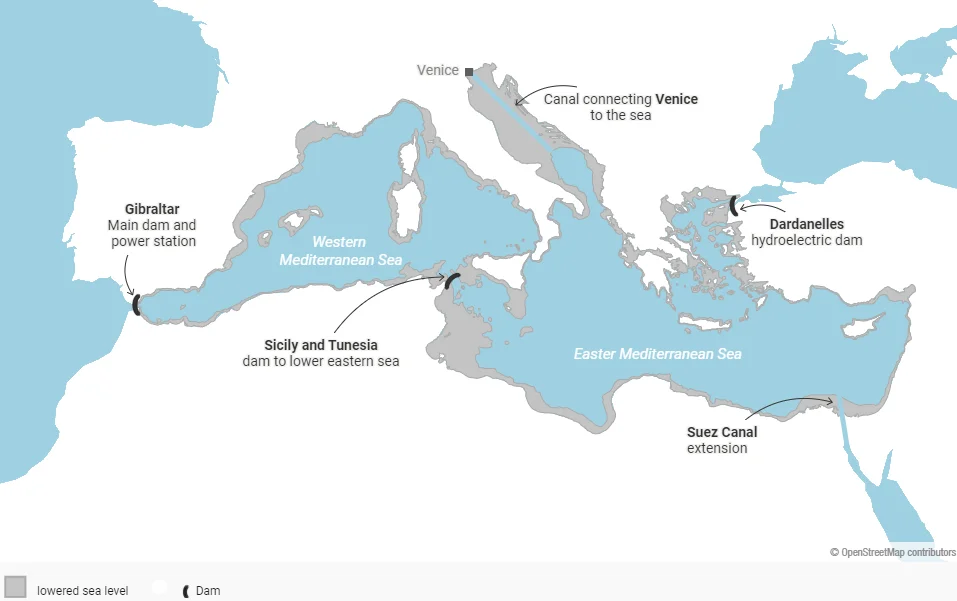
All these projects pale in comparison to what the German architect Herman Sörgel proposed in 1922. He suggested that Gibraltar and the Dardanelles be blocked with hydroelectric dams, generating an incredible amount of easily accessible electricity! This would lower the level of the Mediterranean Sea by 200 meters, opening up a lot of space for the settlement of peoples, and, among other things, save Venice from drowning and create a land route to Africa! He also suggested irrigating the Sahara and, even more remarkably in light of our topic, building dams on the Congo to create a lake that he called the Congo Sea.
All of this would help moderate the climate and make it easier for Europeans, who were suffering from a lack of living space, to develop new territories. It was a peaceful way to expand space, unlike the one proposed by the Axis powers. No attention was paid to what would happen to the inhabitants of the African countries or the flooded regions.
But Jules Verne thought about it in his penultimate novel, L’Invasion de la mer (Invasion of the Sea), published in 1905. It describes just that scenario—the creation of the Sahara Sea by flooding the salty lakes of Melrhir and Djerid, in present-day Algeria and Tunisia, respectively, through a canal from the Mediterranean. It also paints a vivid picture of the confrontation between the engineers and workers and the indigenous people, who, for some reason, did not support the Europeans’ plans. Spoiler: in the finale, the leader of the locals dies in the newly created sea, and the Europeans captured by him are rescued.
Atlantropa project/Wikimedia commons
Herman Sörgel’s project became known as Atlanthropa or Panropa because as the result of its realization would be a united continent of Europe and Africa. It is noteworthy that the project was not popular in either Germany or Italy. However, its author survived the Second World War and continued to promote his ideas until his death (he was hit by a passing car while riding a bicycle) in 1952.
ON A TRULY AMERICAN SCALE
Surprisingly, in the second half of the last century, efforts were made, not only in the Soviet Union but also in the United States, to use the water of the northern rivers ‘uselessly’ flowing into the Arctic and Pacific Oceans. The first version of the plan to divert the flow of Alaskan rivers through Canada to the western United States was developed by the U.S. Army Corps of Engineers, and the feasibility study was made by the Parsons Corporation in 1964. The plan was called the North American Water and Power Alliance, or NAWAPA. Apparently, it seemed unfair to American engineers that freshwater from the Yukon, Peace, and Liard rivers flowed through desolate, frozen areas with virtually no population, while tens of millions of people in Colorado, Nevada, Utah, Arizona, and especially California, as well as northern Mexico, depended only on the single Colorado River. The lack of freshwater in the western United States is just one of the problems the NAWAPA plan was designed to address. It included 369 separate engineering projects and was estimated to cost $100 billion in 1975 (about $640 billion today).
This money was to be used, among other things, to build a series of reservoirs, including the main one, which would be 800 kilometers long, in a valley in the Rocky Mountains,ithe Rocky Mountain Trench, also known as the Valley of a Thousand Peaks to dig a navigable canal from the Canadian province of Alberta to the American Great Lakes (thus, among other things, stabilizing their levels), and to build many powerful hydroelectric power plants. Water from the north of the continent would be pumped over the Rocky Mountains (which would provide a significant portion of the electricity generated) and transported through a system of canals into the Colorado and Rio Grande river systems. The Mississippi, Missouri, and Columbia rivers would receive additional water through the canals, and Mexican farmers in the states of Baja California and Sonora would have enough water. Additionally, the waters of the Colorado River would even begin to reach the Gulf of California, which had not happened much since the construction of the Hoover Dam in 1936. As in the Soviet Union, the proposal to carry out earthworks using, among other things, nuclear charges was made.
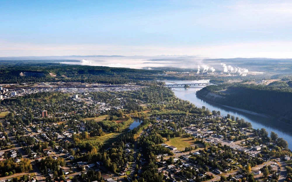
Prince George is a city in Canada that was proposed to be flooded as part of the NAWAPA project/Wikimedia commons
What then prevented the implementation of such a wonderful plan? Apart from the inevitable destruction of ecosystems and the need to relocate hundreds of thousands of people, it was the dissatisfaction of the public, especially environmentalists—as it was in the Soviet Union too. The cost was also staggering: for the entire Apollo program, from 1960 to 1973, the US spent less than $30 billion, which was less than a third of the estimated cost of NAWAPA, which would have inevitably increased as the work progressed. As historian William deBuys wrote, NAWAPA died a victim of its own grandiosity.22NAWAPA was not the only such plan in North America. An alternative was proposed in Canada, and it was called simply and sonorously the GRAND Canal, or Great Recycling and Northern Development Canal. Its creator, engineer Thomas Kierans, made a proposal to dam the James Bay, a part of the Hudson Bay, and turn it into a freshwater lake (many rivers flow into it, and without communication with the ocean, the salinity of the James would gradually decrease), and then, if necessary, to pump water from it, using the new GRAND Canal, into Lake Huron, thus solving the problem of lowering the water level in the Great Lakes. The author promoted his project from 1959 until his death in 2013, but never succeeded because, as in the case of NAWAPA, the GRAND Canal threatened enormous construction and maintenance costs as well as colossal environmental damage, with needing to relocate entire cities that would be in the path of the water.
RIVERS THAT FLOWED TO THE RIGHT PLACE
In addition to the Soviet Union and the United States, the People’s Republic of China has also dreamed of a megaproject of transferring river flow from regions where water is abundant to regions where it is scarce. There, the full-flowing and willful Yangtze River flows from west to east through the southern parts of the country, where there are no problems with water resources, occasionally (before the cascade of hydroelectric power plant construction) causing floods. At the same time, in the north of China, where Beijing and many industries are located, water is scarce and the climate is dry. The solution? Dig a canal, or rather three canals, to send the ‘excess’ water from the Yangtze north. Chairman Mao liked this plan back in the early 1950s, but it was only in 2003 that it began to be implemented very vigorously—$80 billion was spent within ten years.
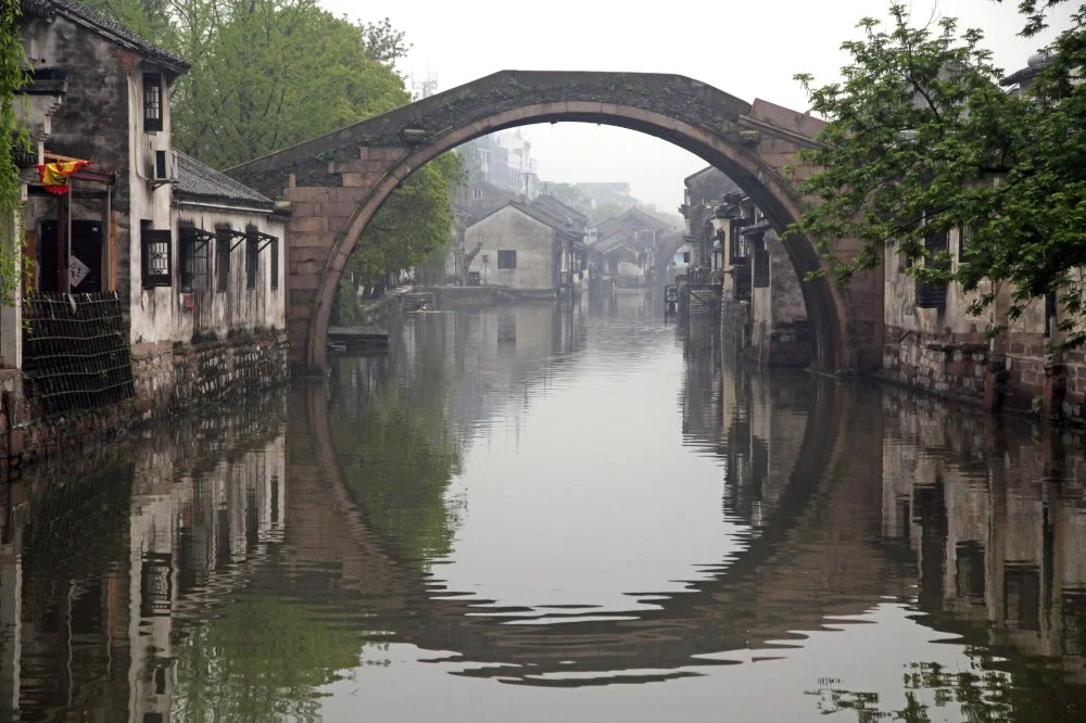
Huzhou,Zhejiang,China/Alamy
China has a long history of megaprojects. As early as the fifth century BCE, they began building a system of hydraulic structures designed to create a waterway (and divert some of the flow) from south to north, from the Yangtze to the Huang He. It passed through lakes, included man-made channels (up to 3 meters deep and 350 meters wide), dams, and, after the tenth century CE, sluices (just invented in China at that time) to overcome the uplands. In the 1280s, this waterway of about 1,800 km reached Beijing and connected it to Hangzhou by water. And all this, mind you, was accomplished using only the hands of workers, not heavy machinery or nuclear charges. In the centuries that followed, the system modernized and evolved, playing a huge role in unifying the country and developing trade and crafts. It still exists today, known as the Grand Canal, and is a UNESCO World Heritage site.
Today, three canals are yet to be built: the Eastern Canal (using part of the infrastructure of the Grand Canal), the Central Canal (along the North China Plain), and the Western Canal, which will take water from the upper reaches of the Yangtze, Mekong, Huang He, and other rivers. The Western Canal is the most difficult to build because China’s neighbors who use the water of these rivers oppose its construction, the project is too complex, and the demand for it is not clear. The other two, however, have either been built or are under active construction. They include numerous pumping stations, dams, sluices, and even tunnels through which water from the Yangtze and its tributaries, especially the Yellow River, can flow.
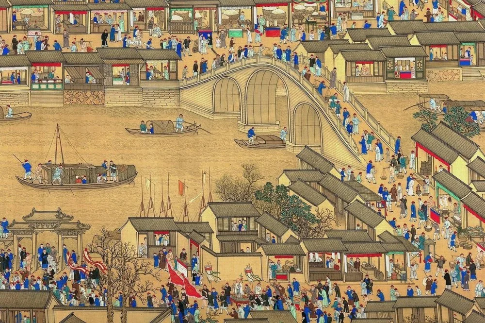
Grand Canal (China). Medieval art/Wikimedia commons
Of course, none of this would be possible without the relocation of people on a truly Chinese scale—at least 330,000 people in central China are expected to be relocated. Nevertheless, of all these fantastic projects, the Chinese one is the closest to being fully realized.